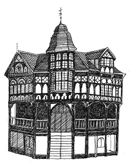
An A2 map of the Rows, the famous historical shopping district of Chester - full of double tiered Medieval and Medieval style buildings - taking the reader on a walking tour through its heritage from the Romans to the Victorians via the English Civil War and a broad history of commerce.
The map was based on a 17th century style map in black and white with a flat perspective and decorative borders and cartouche. It's available as a downloadable map with a printed version planned.
You can read more about the making of the map here.